Log In
/-81.449182033539,30.444326480785,12/500x250?access_token=pk.eyJ1Ijoid2F0ZXJ3YXlndWlkZSIsImEiOiJGRmM1RDdzIn0.Wya5yV5QEqbz0-fct8zyIA)
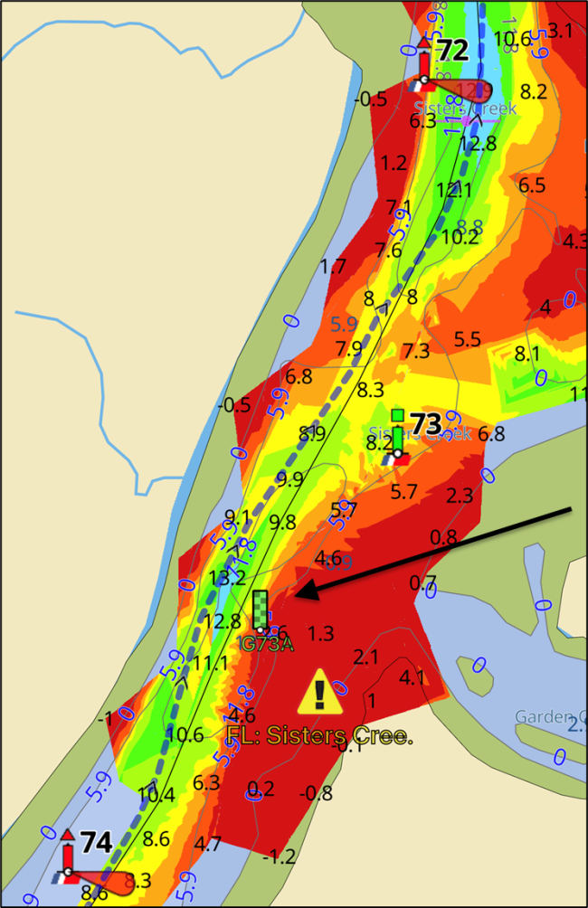
FL: Sisters Creek by G73/R74, MM 735
- Date Reported: Jun 20, 2024
- Reporter: Bob423
- Source: User
- Description:
Update: 6.9 MLLW as of 5/15/2024 on the Bob423 track.
Heading south, pass R72 in the middle of the channel, then favor the green side of the channel to avoid the shoaling north of G73. Then switch over to the red side of the channel by G73 and return to the center of the channel by R74 or follow the Bob423 track. The 8/27/2021 USACE survey is shown with the Bob423 track.
An additional green buoy has been added but it is not on most charts. It's shown on the chart with an arrow as G73A and marks the eastern edge of the shoal.

USACE = US Army Corps of Engineers
ATONs = Aids TO Navigation such as buoys and daymarks
Aqua Map = a navigation app for Apple and Android devices
Bob423 track = blue dotted line
Link to video on how to download tracks - Lat / Lon: N 30° 26.660' / W 081° 26.951'
1 Boater Comment
-
Comment by: Teresa Scott on May 3, 2024
Vessel Type: Sail
LOA: 40'
Draft: 5.5'Came through about an hour before low tide. Never saw less than 7.5
View location on the Waterway Guide Explorer


