Log In
Thanks for your valuable feedback!
/-81.468815803528,30.53820129131,12/500x250?access_token=pk.eyJ1Ijoid2F0ZXJ3YXlndWlkZSIsImEiOiJGRmM1RDdzIn0.Wya5yV5QEqbz0-fct8zyIA)
FL: S. Amelia River by R44, MM 728
- Date Reported: Jun 5, 2023
- Reporter: Bob423
- Source: User
- Description:
Update: 9.3 MLLW as of 4/27/2023 on the Bob423 track.
This area was dredged 3/2019, just follow the ATONs. The 4/8/2019 USACE survey is shown in Aqua Map with the 5/13/2020 Bob423 track as a blue dotted line.
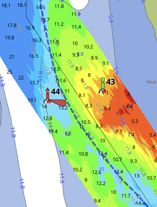
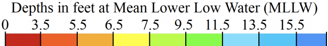
USACE = US Army Corps of Engineers
ATONs = Aids TO Navigation such as buoys and daymarks
Aqua Map = a navigation app for Apple and Android devices
Bob423 Long Track = blue dotted line
How to download tracks - Lat / Lon: N 30° 32.292' / W 081° 28.129'
1 Boater Comment
-
Comment by: Teresa Scott on May 3, 2024
Vessel Type: Sail
LOA: 40'
Draft: 5.5'Coming through at low tide saw 8.7 feet.
View location on the Waterway Guide Explorer


