Fernandina Beach Shallows Still a Problem
Date Posted: March 9, 2018
Source: Bob423

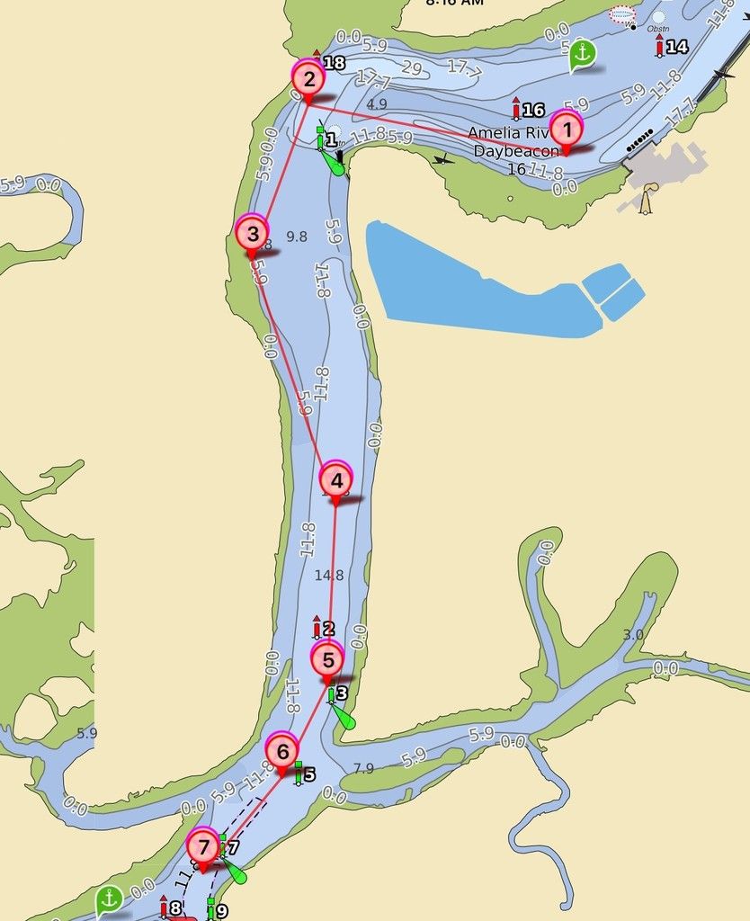
The shallows south of Fernandina have a long history of agitating boaters. There are at least four unmarked shoals that can catch the unwary captain. Until recently, the buoy placement did not provide guidance around the shoals. A deep-water path was surveyed in 2016 for which I posted waypoints used by many boaters successfully. In November of 2017, the deep-water path was further dredged, making it the official ICW channel. Three new buoys were added and all was thought to be fine. However, it appears there’s more than one way to interpret how to pass through those buoys and there have been a number of groundings. 

Shown below is a chart showing the new buoys. The blue line is a route that appears to honor the buoys but may encounter a shoal from G1 to G1A. The red line is the route recommended by the Coast Guard after the dredging of 11/2017. The red line route follows the centerline of the channel survey after the dredging.


A chart of the entire red line route is shown below. A GPX download of the route is available in the Nav Alert listing on the Waterway Explorer.

It is highly recommended that the GPX route be loaded into a nav program due to the lack of enough buoys to guide you through around the shallows. 

Waterway Guide is continuing its assessment of this channel and will publish updates as they become available.
Comment Submitted by Robert Sherer - March 16, 2018
Aqua Map sells an Android version as well as an Apple version for tablet navigation. Give it a try. I use the Apple version but the company said both will download GPX charts for navigation.  
Comment Submitted by Cheryl - March 10, 2018
This is wonderful, however not all have iPads. Would be helpful if info would be given for Android folks. 
Comment Submitted by Capt Gene of "Galene" - March 9, 2018
3 9 2018 We transited here twice last week and had no problems. The Red path works well. You need to stay away from the G1 day mark and steer towards red side as shown on red path. When coming from the South Northbound you need to look for G1B as it is on the west side of channel. If you do not and see the G1 daymark you will line up out of the channel looking at G1. I have observed people making this mistake as the bouy does not stand out and is very easy to miss.
Explore More News & Articles In Specific Cruising Areas
Recent Videos
Plan Your Boating Adventures with Waterway Guide
Waterway Guide's new Mobile App on iPad Mini with maps, data links, and downloadable guide books
Fuel Prices for Boating at Waterwayguide.com
Purchase a Guide
  • 4,000 Marinas
  • Thousands of anchorages
  • Updated Charts
  • Mile-by-Mile Navigation
  • Highlighted Alerts & Cautions
  • Full-Color Aerial Photographs
Download The App

The Waterway Guide App Makes it easy to leave reviews, use our explorer, and view waterway guide materials all on the go!