Now that we've enjoyed a relaxing winter down south, it's time to prepare your navigation tools for the cruise back north. Even if you've spent the winter huddled up north counting snowflakes, you may have the same concerns on how best to get ready for your summer cruise. You should also consider new tools not available last year and new capabilities for the tools you already have. Let's review a few steps to prepare your navigation tools for summer use.
1 – Update your navigation apps and software to the latest level.
Manufacturers are adding new features all the time and fixing bugs found by their users. For Apple tablets and phones, you can choose auto or manual updates. Android apps can also be auto or manually updated. In addition to all your apps, be sure to update the operating system of your Apple or Android tablet and test for problems before setting out on your trip north (see Fig 1). You want to find any issues while you're near WiFi and not on the water when approaching a shoal area requiring a tricky maneuver.

Most PC software has an option to check for updates in the Help tab; if not, go to the program's home webpage, compare the latest release to the copy you have, and update if needed. As an example, here's the update page for OpenCPN. While you're at it, check all the plug-ins for your PC software; they may need updating too.
Chartplotters also need updates, not only for charts but also for their internal software (called firmware). After all, a chartplotter is just a fancy minicomputer, and they are getting more complicated all the time, with the attendant chance for software bugs. Keep your chartplotter up to date to take advantage of problem feedback on all devices and the resultant fixes.
The updating procedure varies by manufacturer. Garmin has an all-in-one update tool for charts, chartplotter firmware, and device syncing. Raymarine has a more manual process that requires entering the device name and choosing from a list. Other manufacturers have similar updating procedures. Don't forget the internal software (firmware) that runs your radar, gateway, AIS receiver, and even the helm instruments in your search for what to update.
2 – Practice Forming and Using Routes and Tracks
The first step is to become proficient in using your navigation system. Manuals seem to vary from thick booklets with pages and pages of fine print or no guide at all, or you're expected to sit through endless tutorials. Apart from the basics of selecting the units you want, loading charts, etc., practice in:
- Forming a route
- Recording a track
- Importing a route or track
- Exporting a route or track

Fig 2 shows a typical route in Aqua Map
Why bother to learn these procedures? Some cruising areas vary year to year faster than NOAA can update the charts or the Coast Guard can move ATONs. The Atlantic ICW, in particular, is prone to shoaling, and local knowledge in the form of an imported GPX track, route, or other crowd-sourced data can be invaluable in finding deep water through a shoaling area. Even in stable areas, you may just want to plan your trip for stays in anchorages and marinas or trade routes with your cruising group. Practicing now in the quiet of your cabin or home is a good way to brush up on these skills before setting out for the summer.
3 – Become Familiar with the Use of Waterway Guide Alerts

When you form your routes, you will need a source of information on where hazards are located and how to avoid them. Even if you just use the Bob423 Tracks, which avoid shoals when first published, there may be shoaling that happens so quickly that not only do the ATONs and charts not account for it, but even the Bob423 tracks may lag. Additional resources build confidence in your route, but where can you go for information you can trust? Before you're on the water with all the distractions, now is the time to explore these sources and become familiar with their use. Waterway Guide Alerts are kept current by Waterway Guide Editors for the US East Coast, the Loop, Great Lakes, the Bahamas, and more. The Alerts cover hazards, bridge and lock schedule changes, and anything else affecting mariners. So the first source to check in planning your voyage are the Alerts along your route. Also, recheck the Alerts for changes before setting out for a day's run. The Alerts can be accessed in several ways:
- By going to Waterway Guide Explorer, panning along your projected path and clicking on the Alert icons. Note the Alert icon in Fig 4. Clicking on the icon shows details on the hazard and guidance for a safe passage.
- By panning along your route in Aqua Map and tapping on the Alert icons.
- By subscribing to Waterway Guide's emails on all Alert updates in your area, they will be delivered to your inbox as soon as they are issued.
Practicing now can speed access to vital information when quickly needed on the water.
Once you have a safe passage route saved, Waterway Guide can help you plan the rest of your trip. Take a moment to look over additional offerings.
- Waterway Guide allows you to explore your entire route, not just the trouble spots. After all, stopping along the way to enjoy the towns and sights is a part of the cruising lifestyle.
- Publications by region are available for 10 cruising areas for more details on enjoying the areas
- Knowledge Center for the latest news on all cruising areas, such as my articles on the Top Five Navigation Hazards for Spring 2025 and in Preparing your Home and Finances for Extended Cruising.
- An Inside look at selected marinas. Here's one example.
- Waterway Guide's Digital App allows access to all publications with an iPhone or tablet.
4 – Learn to Use Trusted Routes or Tracks for Reference
There are many online sources of tracks and routes that can be downloaded for reference in forming your route. The Bob423 Tracks are one popular aid for those traveling the Atlantic ICW. They come in the form of four GPX files from Norfolk, Virginia, to Miami, Florida. They follow the deepest water in the ICW, avoiding the shoals, and are updated throughout the year as conditions change. Hundreds of boaters traveling the ICW use the Bob423 Tracks —and they are free. Practice downloading them to your app or navigation software if you plan on traveling the Atlantic ICW. They can at least be a reference for your planning.
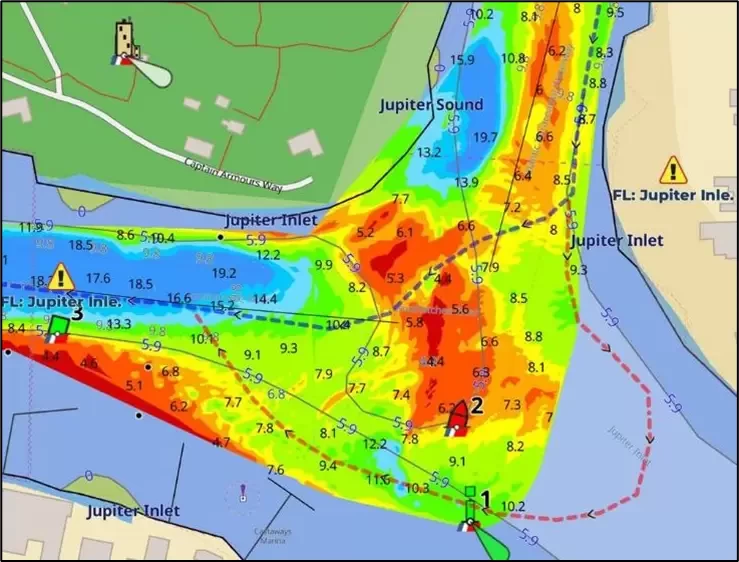
Fig 3 shows a track through Jupiter Inlet. The red track is an alternate track for deep water when the NOAA channel is shoaled (shown in blue).
Learn the Use of Bob423 Tracks if Cruising the ICW
- Quick review of Rules of the Road
- How to automatically sync Bob423 Tracks (if you use Aqua Map)
- How to download Bob423 tracks (for all other navigation devices)
- Bob423 download page. Here's where the tracks are stored for downloading (if you already know the above). The essential advice here is that the tracks must be updated. Before setting out in the morning, be sure you have the latest track for your area by checking this page.
Friends or your cruising club could provide routes or tracks from many other areas that may help your planning. Having the tracks or routes of a person who previously cruised an area (successfully!) can help build confidence in your routes and avoid pain to your pocketbook.
5—Take Advantage of Bob423 Guides
The ICW Cruising Guide is updated yearly and covers the shoaling areas of the Atlantic ICW. The guide includes a chart for each shoal and instructions for safely navigating around it.
The book contains extensive information on what one needs to know in cruising coastal waters. It is available in several formats:
- Digital format: Waterway Guide digital guide 2024 ICW Cruising Guide.
- Hardcopy: 2024 ICW Cruising Guide book from Amazon.com or Landfall Navigation.
- The Atlantic ICW Chartbook covers from Norfolk to Key West and across Okeechobee to Ft Meyers and is available from Landfall Navigation in spiral binding or Amazon.com in standard binding for those wishing charts in the NOAA paper chart format. For sample pages, see RNC Samples.
- The Long Island Sound chart book covers from New York City to Block Island and the north and south shores of the Sound in the NOAA paper chart format.
Join The ICW Cruising Guide Facebook with 23,800 members if you're cruising the Atlantic ICW. Members report what they see daily and give feedback on depths at shoaling areas and bridge problems on the Atlantic ICW. The information is in real time as experienced by boaters on the water. Look for other cruising Facebook pages covering areas you will be cruising. The real-time feedback is invaluable on sudden shoaling or bridge closures.
6 – Learn New Ways to Use the Local Notices to Mariners (LNMs).
The Coast Guard implemented a graphical interface to Local Notices to Mariners (LNMs) this year that all cruisers need to know how to access.
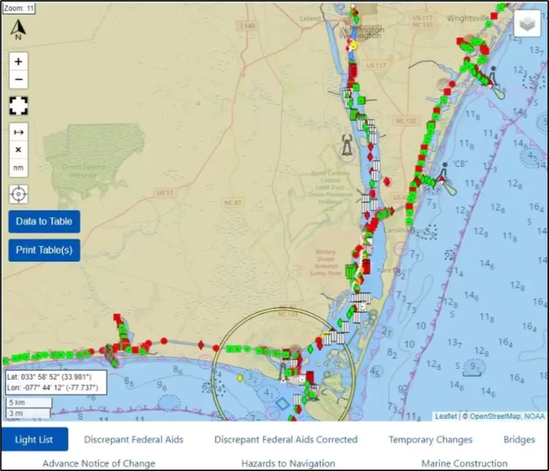
- Maritime Safety Information Products (MSIP) is a new webpage by the Coast Guard for the viewing and downloading of notices. You used to download a 100+ page PDF once a week and pour through the densely worded notices from each District of interest to find something affecting your route. That has changed with their new webpage, All the information across all Districts has been centralized in one graphical interface, updated every 15 minutes.
You can pan the chart to your cruising area, and with a click on the icon "Data to Table", you get a table of all Coast Guard notices affecting the area in the field of view of the chart. This is a great time saver. There's lots of data to see, and you need to learn how to use the website. It's much faster than downloading multiple PDFs and searching manually to find the info. For complete instructions and examples of how to use the new interface, see Use of MSIP. A sample page is shown in Fig 6.
- The Waterway Guide Explorer chart shows the LNM notices most affecting the cruising mariner. You will see bridge and lock schedule changes, shoaling alerts, and ICW closures—all in the Alert category of the Waterway Guide. Just pan to your cruising area, and the Alerts in the area (yellow exclamation point) will list notices affecting your cruising.
- Aqua Map has a new capability this year of displaying Local Notices to Mariners (LNMs) directly within the app. If there is dredging in an area, it will display a shaded area showing the dredging plans. If there is a report of shoaling by the Coast Guard, it will display the boundaries of the reported shoaling. All ATONs that are damaged, off-station, missing, etc., are also displayed, along with 16 other categories of LNMs. The data comes from a Coast Guard digital file automatically without the need for any human interface, so it's quick to display the Coast Guard data, and it's updated every 15 minutes.
Ready for Cruising: With the topics covered, you are better prepared for your migration north and summer cruising:
- You updated all your navigation devices and software.
- You're adept at forming routes and tracks.
- You can quickly find hazards along your route
- You can import reference tracks and routes
- You can use the new graphical interface to find Local Notices for Mariners for your area
The suggestions in this article are intended to make your next cruise more enjoyable. After all, who wants to sit on a shoal and wait for a BoatUS tow when the grounding could have been avoided by looking at the sources listed in this article? Take time to practice accessing the information you will need in the quiet of your cabin or home, so when you start your cruise, you're already thoroughly familiar with how to get the latest info without a learning curve delay. Learn now for quick access later.
After all, it's a pleasure to cruise the US waterways - why risk a grounding or wrong turn when a little planning allows for a more enjoyable experience? Cruising should be fun and not interrupted by the "excitement" of a sudden grounding.
Safe travels, Bob423


- 4,000 Marinas
- Thousands of anchorages
- Updated Charts
- Mile-by-Mile Navigation
- Highlighted Alerts & Cautions
- Full-Color Aerial Photographs

The Waterway Guide App Makes it easy to leave reviews, use our explorer, and view waterway guide materials all on the go!