The Atlantic Intracoastal Waterway (AICW) is constantly changing like no other waterway in the world. If you're headed north on the AICW this spring, it pays to be aware of the new problems and how to avoid them. Here are the Top Five that have shoaled during the winter. We'll start with the ICW crossing at Jupiter Inlet and go north from there.
1 - Jupiter Inlet at MM 1004 🔗
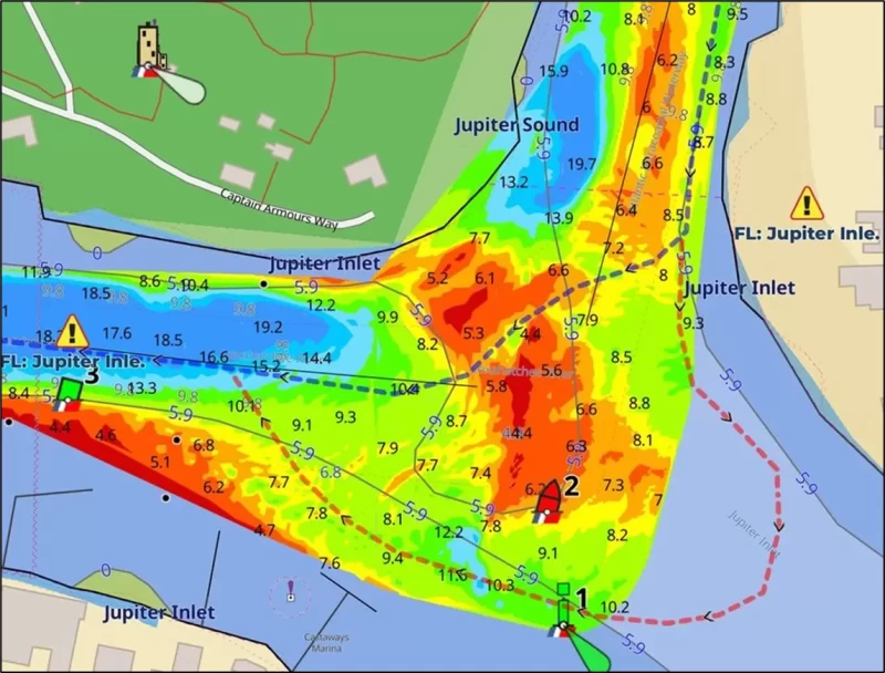
If you follow the AICW channel you will see less than 3.3 MLLW. The 1/30/2025 USACE survey is shown, but the shoaling will increase in the weeks ahead. However, there is a way to avoid the shoals by going out the inlet a short way, turning in a slow 180 degrees and returning to the AICW, as shown by the red dotted line, which is part of the Bob423 track for Titusville to Miami. It's free for download at Bob423 Downloads and gives 8.0 MLLW.
So far there are no plans to dredge the AICW crossing at the Jupiter Inlet in 202. See the Waterway Guide Jupiter Inlet Alert for the latest information on the extent of the shoaling and the best path through the hazard.
2 – Ponce de Leon at MM 843🔗
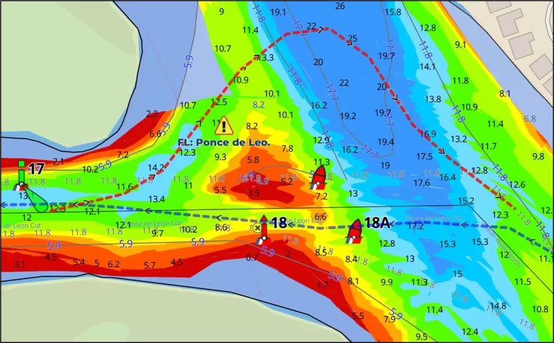
The route using the NOAA official channel is very narrow and down to 6.4 MLLW, even on the Bob423 blue line. Furthermore, staying on that route is hampered by cross currents from the inlet, not to mention oncoming boats. A better strategy is to use the alternate route shown as a red dotted line that has never shoaled, which is good for 10.1 MLLW. The 9/14/2023 USACE survey is shown. For the latest information see the Waterway Guide Ponce de Leon Alert.
3 – Isle of Palms at MM 460🔗
Isle of Palms is shallow to bare sand at low tide in the channel. You may be able to plow through "mud fluff" in areas like Ashepoo Coosaw and McClellanville, but not in the Isle of Palms where the bottom is unforgiving sand. Fortunately, you can use tide and go outside the channel for 4.3 MLLW, as shown by the blue dotted line, or avoid the shoal altogether by following the red dotted line for 6.7 MLLW. The 2/3/2025 USACE survey chart is shown. There are dredgers in the area, but unfortunately, they are not dredging the shallow area. They are moving sand from a storage area to a nearby beach. You will see a row of red floats along the bypass route; you can pass between them at the southern turn. I recommend taking the red dotted line; it's included as part of the Bob423 track for the area. Be sure to check the Waterway Guide Isle of Palms Alert for the latest information as the shoaling is changing constantly. 
4 – Lockwoods Folly Northern Approach at MM 320🔗
The Lockwoods Folly River is coming in from the north by G1, causing shoaling in the channel to 2.1 MLLW. You can go outside the channel on the green buoy side for 6.0 MLLW, as shown by the blue dotted line, which is the Bob423 track. Be careful in following the track through here; the deep water is only 40 ft wide at low tide. On the chart you can see a black line joined by two white dots, which is an underwater obstruction found by several boats. Take care.This is an active shoaling area. For the latest guidance, see the Waterway Guide Lockwoods Folly Approach Alert. On occasion, R36 has been reported off-station; follow the Bob423 track to be sure. 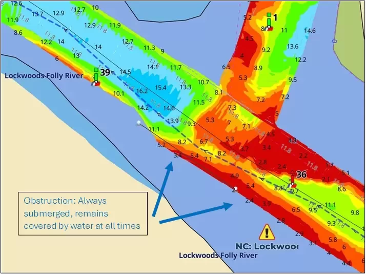
5 – Mason Inlet at MM 280🔗
There is shoaling to 2.6 MLLW in the channel. The blue dotted line is the Bob423 track; it goes outside the channel on the red buoy side to find deeper water for 6.6 MLLW. Check the Waterway Guide Mason ICW Alert for the latest update.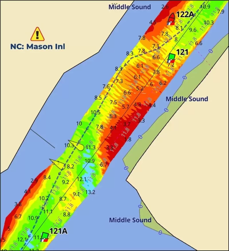
The other shallow areas of the AICW have not changed much; they are still shallow except for Browns Inlet, which was recently dredged. For a complete list of all shallow areas, there are several choices:
- Search through the Waterway Guide Alerts on their webpage.
- Click on the Aqua Map Waterway Guide Alert icons along your planned passage.
- Access the Waterway Guide digital guide 2024 ICW Cruising Guide.
- Get a copy of the 2024 ICW Cruising Guide book from Amazon.com or Landfall Navigation.
A chartbook covering the Atlantic ICW to Key West and across Okeechobee to Ft Meyers is available from Landfall Navigation in spiral binding or Amazon.com in standard binding for those who want charts in the traditional NOAA paper format. Consider downloading the Bob423 tracks as a reference for safe passage.
Being fully informed of hazards ahead is key to having a successful voyage!


- 4,000 Marinas
- Thousands of anchorages
- Updated Charts
- Mile-by-Mile Navigation
- Highlighted Alerts & Cautions
- Full-Color Aerial Photographs

The Waterway Guide App Makes it easy to leave reviews, use our explorer, and view waterway guide materials all on the go!