1 - MM 84 Alligator River Marina to close Dec 1st
It's the only marina between Coinjock and Dowry Creek Marinas, a distance of 82 NM. It's a convenient stop for a captain not wanting to anchor out or with pets. The marina will be dedicated to the vessels and crew building the new high bridge starting Dec 1st with no room for transients. The closing date may slip again, so call ahead to check.
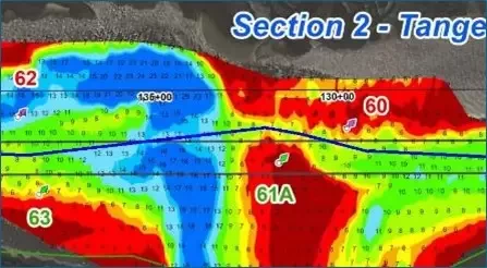
2 – MM 238 Browns Inlet, severe shoaling to 5 – 6 MLLW in Bob423 track as of 11/4/2024
The 5 to 6 MLLW path is out of the NOAA channel, away from G61A. If you try to go straight through, you will encounter 1 MLLW. The Coast Guard may eventually move G61A to mark the shoal, but do not depend on it. Use the Bob423 track for passage.
Warning: Browns Inlet continues to shoal and the present 30 ft gap of deepest water may shrink even further. I advise using tide with the Bob423 track. Go slow, the bottom is unforgiving sand.

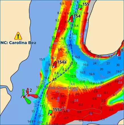
3 – MM 293.7 Carolina Beach shoaling to 4.2 MLLW in NOAA channel.
The ICW at Carolina Beach Inlet requires a curved path as shown by the Bob423 track. A straight through path honoring the ATONs would put you into shallow water to 4.2 MLLW. The Bob423 track shown by the blue line gives 7.7 MLLW as of 10/10/2024.

4 – MM 843 Ponce de Leon alternate route for 13.1 MLLW
The NOAA channel by R18 and R18A continues to narrow. It was only 6.4 MLLW as of 5/7/2024 and less than 30 ft wide, but it is probably less now. The alternate route shown in red on the photo was sounded to be 13.1 MLLW on 11/13/2024.
Consider taking the alternate route if passing through at low tide. Ft Matanzas at MM 792.5 was 10.8 MLLW as of 11/12/2024 on the Bob423 track.

What's the secret? It's simply that the captain plans ahead to pass the shallow spots with tide. You can too with the right planning aids below:
Use Waterway Guide Alerts to plan your trip, adjusting timing for the tide you need.
Follow the Bob423 tracks in Aqua Map to ensure you get the maximum depth possible and USACE surveys.
The areas mentioned in this Bulletin are only the recent changes, not a complete picture of all shoaling. Additional resources are available in the Waterway Guide digital publication 2024 ICW Cruising Guide by Bob423.


