MM 45.6 "Eric's Shoal" in middle of the channel
Groundings have been reported this week north of Coinjock in the middle of the NOAA channel as shown on chartplotters. The NOAA charts are offset in this area and the middle of the channel is actually the edge where it's shallow.
"Eric's Shoal" takes its name from a report last year by a captain who rigorously maintained he was in the middle of the channel per his Garmin chartplotter and yet still grounded with his 5 foot keel. He posted his Lat/Lon coordinates as a waypoint shown in the photo. Note that the waypoint is mid-channel on the NOAA chart but on the edge of the channel on the USACE survey in Aqua Map. He thought he was in the middle when he was actually on the edge of the channel into shallow water.
The NOAA chart is offset in Lat/Lon in this area. Following only your chartplotter can lead you astray. The blue dotted line is the Bob423 track, which follows the centerline of the deepest water. As you pass through this area, follow the channel with the Bob423 track or use Aqua Map with the USACE survey to stay in deep water. The link in red will display a PDF file with a more detailed explanation.

MM 240.7 Onslow Bridge is Closed 11/18 to 11/21 (see details below)
Schedule for boats with a vertical clearance of 15 Feet or less and 20 feet in width:
These vessels can transit through the bridge during all periods but may have to wait for an opening of the old bridge on top of the hour if more than 12 feet in height.
Schedule for boats with a height greater than 15 Feet
Onslow Bridge will be closed on 11/18 at 7:00 a.m. until 11/21 at 9:00 p.m.
On weekends, all boats can transit:
- 7:00 am to 7:00 p.m.: opens on top of the hour
- 7:00 pm to 7:00 a.m.: opens on demand
For Weekdays, Onslow Bridge will open as follows:
- Noon to 1 p.m.: Onslow Beach Swing Bridge opens on demand for all vessels.
- 5:00 pm to 7:00 p.m.: Opens on top of the hour for all vessels
- 7:00 pm to 7:00 a.m.: Opens on demand for all vessels
With the Onslow Bridge closure for four days starting 11/18, the Mile Hammock Bay anchorage is a popular stop on the way south after pushing to pass through the Onslow Bridge on Sunday, 11/17, before closure the next day. At the last closure period, over 27 boats were anchored by 1:30 p.m. on Sunday with more looking for room later on.
You may want to plan ahead for the expected crowded conditions on 11/17 or move farther south for the night.

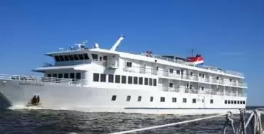
 Don't be overly concerned about shallow areas. After all, if the captain of the Independence (pictured) can pass through all the famous shallow spots, you can too.
To many first-time ICW boaters, reading about all grounding reports can be scary. It pays to remind boaters that American Cruise Lines has vessels with 8.5 foot drafts that cruise the ICW from Norfolk, VA to Amelia Island, just south of Fernandina, FL. The vessels go through all the famous shallow spots like Hell Gate, Isle of Palms, and more.
What's the secret? It's simply that the captain plans ahead to pass the shallow spots with tide. You can too with the right planning aids below:
- Use Waterway Guide Alerts to plan your trip, adjusting timing for the tide you need.
- Follow the Bob423 tracks in Aqua Map to ensure you get the maximum depth possible and USACE surveys.
The areas mentioned in this Bulletin are only the recent changes, not a complete picture of all shoaling. Additional resources are available in the Waterway Guide digital publication 2024 ICW Cruising Guide by Bob423.


