Being a prudent mariner, you plan your trips on the Intracoastal Waterway (ICW). You prepare yourself with the latest references from Waterway Guide and Bob423. You plot your course in your favorite navigation program such as Aqua Map, Navionics, or Multifunction Display (MFD). You're all set – or are you?
In the midst of all your efforts Mother Nature decided to stir things up with a hurricane or two across your path. Is all your work for naught? We've all seen pictures of rivers of debris-filled water flowing from hurricane downpours, not to mention strong winds pushing water ashore. We might expect a lot of shoaling from the wind, surges, and rain. But looking at before and after surveys by the US Army Corps of Engineers (USACE) for two hurricanes that tracked down the ICW with devastating winds and record down pours the situation is not as dire as it may seem.

First up is Hurricane Matthew, which set records for rainfall in 2016. It tracked along a very sensitive portion of the Atlantic Intracoastal Waterway (AICW) where there are many shoal areas. Two of the most infamous ones: Lockwoods Folly at mile marker (MM) 321.5 and Shallotte at MM 329 seem prime for being adversely affected.
First, look at the effects of rainfall on new shoaling. The rainfall was historic at the time, breaking 100-year and 50-year records. Hurricane Florence smashed those records later but look at Matthew first.
Rainfall amounts that topped 50- and 100-year records would seemingly affect shoaling. But when you look at the surveys, that's not the case.

This is a survey of Lockwoods Folly on 9/6/2016, a month before Hurricane Matthew on 10/9/2016 (above). It shows a route familiar to boaters on the AICW, one that favors the northern shore. Look at the USACE survey on 10/11/2016 after the passage of Hurricane Matthew. There are no changes that would require a revised route.


Above is Shallotte before Hurricane Matthew on 10/6/2016. Below is after Matthew. The USACE provided a route starting by R82 at the yellow dot and extending towards R80A as a dotted line. There is no difference affecting the boater's course on the dotted line. Next up is Hurricane Florence in 2018.


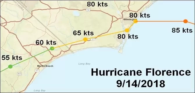
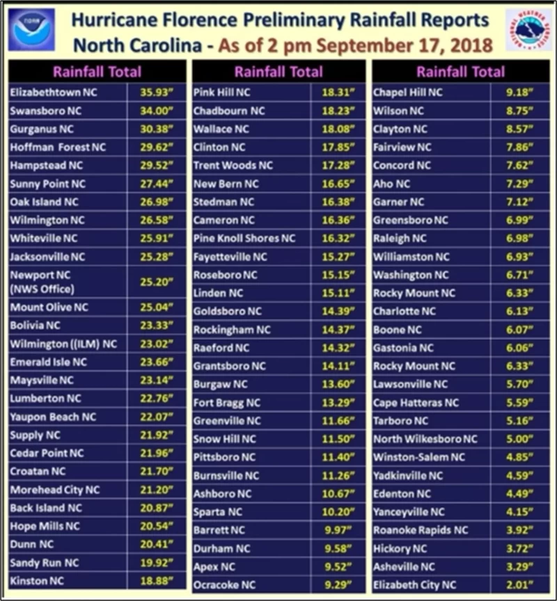
You may say, "Well, Matthew is just one hurricane, and it wasn't nearly as bad as Florence." Here's the path of Florence, with sustained wind speeds (not the gusts). Note that it tracked right down the AICW by Lockwoods Folly and Shallotte. Look at the rain totals from the graphic below.

The totals put Hurricane Matthew to shame with historic levels. Compare the two rain totals.
Elizabethtown, NC saw 18.18 inches from Matthew but got 35.93 inches from Florence.
Swansboro, NC (right on the AICW) saw 3.9 inches from Matthew but experienced 34.0 inches from Florence. The winds were higher and the rain heavier in Florence.
Let's see if that made a difference in shoaling at Lockwoods Folly or Shallotte.

Above is the USACE survey for Lockwoods Folly before Florence swept through on 9/14/2018. Now, let's look at it after Florence, that's the survey below. Can you tell any difference between the two surveys? If you look closely you can see some minute differences but nothing that would affect your route through the area. Next, we'll look at Shallotte.


Above is Shallotte before Florence came through. Below is after. It is tough to see any difference at all. Remember, this is after truly historical rainfall and hurricane-force winds.

It appears that the ICW is not nearly as fragile as you might expect from the effects of hurricanes on shoaling. Obviously, changes occur in some bottom profiles and deposition, but not always in large or noticeable amounts. ATONs are often displaced, marinas damaged, and shorelines affected, but the ICW channel bottom appears remarkably resilient.


