Modal title
Modal body text goes here.
Log In
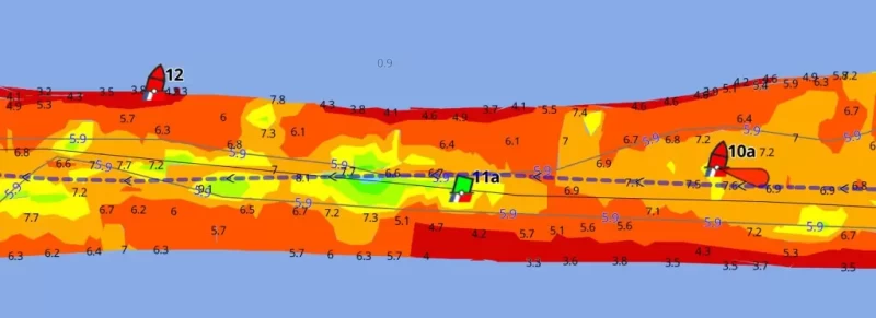
NC: Spooner Creek, Shoaling by R12 ICW MM 210.5
- Date Reported: Dec 20, 2024
- Reporter: Bob423
- Source: Bob423
- Description:
UPDATE: 6.7 MLLW as of 8/28/2024 on Bob 423 track.
Caution: this is a difficult passage with winds of 15 kts or greater due to wave action between the two islands to the south which can push you off track, not to mention oncoming boats in the narrow passage. The 8/28/20224 USACE survey is shown with the Bob423 track. If you deviate off the Bob423 track through here, you can quickly see 5.5 MLLW or less.


USACE = US Army Corps of Engineers
ATONs = Aids TO Navigation such as buoys and daymarks
Aqua Map = a navigation app for Apple and Android devices
Bob423 Long Track = blue dotted line
How to download tracks - Lat / Lon: N 34° 43.365' / W 076° 49.950'
2 Boater Comments
These are observations from the boating community. Waterway Guide information is verified regularly and all efforts will be made to validate any new updates submitted here. Thank you for taking the time to share comments about your experience.
Waterway Guide reserves the option of editing reviews and comments for grammar, clarity and the removal of defamatory or potentially slanderous language. When appropriate, reviews are forwarded to businesses for response prior to being made public. We will make every effort to be objective and impartial when posting reviews, but do not publicize details of disputes between parties.
Current Review Policies
Waterway Guide reserves the option of editing reviews and comments for grammar, clarity and the removal of defamatory or potentially slanderous language. When appropriate, reviews are forwarded to businesses for response prior to being made public. We will make every effort to be objective and impartial when posting reviews, but do not publicize details of disputes between parties.
- Comments are reviewed and/or verified by Waterway Guide staff and do not post immediately. Please use a valid email address so that we can contact you if we need clarification (email address will not be published).
- Name will be published. Anonymous comments may not be posted.
- Comments will be shared with the reviewed marina to offer them an opportunity to respond. If they choose to do so, the marina’s comments may also be posted in response to the original comment.
- Comments containing foul or obscene language will be rejected or returned for resubmission.
- Comments containing personal attacks will be rejected or returned for resubmission.
- Off-topic content will be rejected.
- Comments must describe commenter's personal experience – “hearsay” reports will be rejected.
- Comments must be understandable and clear enough to inform other boaters.
- URL links are allowed only if they inform the content – no “advertising” your business or blog.
-
Comment by: W. Randy King, SV Meander, on Feb 3, 2024
Vessel Type: Sail
LOA: 35'
Draft: 5.5'Stayed on line starboard of 2 red nuns headed North but port of green can. The line took as out of the channel on the chartplotter. We grounded 50 ft North of the second red nun. Had to hang from boom swung out over the water to rock us off. Lost my hat! Immediately returned to channel on charplotter put us back in 8 ft of water. I don't know about the placement of those two red nuns!
View location on the Waterway Guide Explorer
-
Comment by: Francis Gravel on Nov 8, 2023
Vessel Type: Sail
LOA: 36'
Draft: 6.7'At low tide, I keep port of red boys when going south. I saw 5.5'. I slice the sand with my fine keel with 6.5' draft.
View location on the Waterway Guide Explorer
/-76.832499504089,34.722743654463,12/500x250?access_token=pk.eyJ1Ijoid2F0ZXJ3YXlndWlkZSIsImEiOiJGRmM1RDdzIn0.Wya5yV5QEqbz0-fct8zyIA)


